What Planting Zone Is Massachusetts? Understanding the USDA Hardiness Zones
Want to understand the Massachusetts hardiness zones? Here's the updated USDA map with detailed explanations from the Berkshires to the outer Cape.

In 2023 the United States Department of Agriculture updated its longstanding plant hardiness map to reflect changing low temperatures.
Using this Map
The USDA hardiness zones are based on an average of lowest winter temperature over several years. It's meant to be used to determine winter hardiness – some plants won't survive a winter that gets below 0 F (-18 C), for instance. Those plants are much less likely to survive outdoors in zone 7a or colder.
That being said, it's important to remember that these zones are based on averages. Some years will have warmer lowest temperatures, and some will have colder. There's no guarantee that your plant will make it in the zone it's rated for.

It's a good guideline, but take it with a pinch of salt.
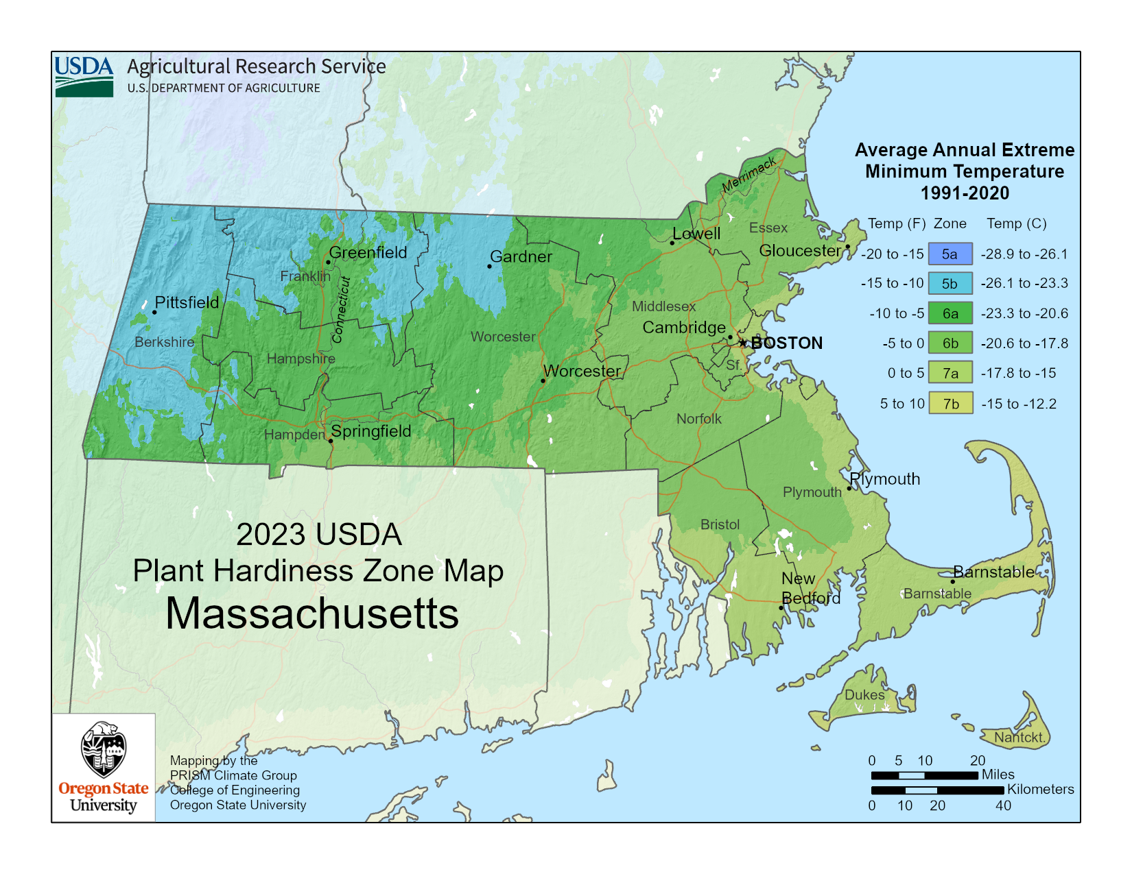
Click on the image above to see a larger version.
The Berkshires
The westernmost part of Massachusetts runs along the border with New York state and climbs up into the Berkshire Mountains. Because this part of the state has the highest elevation, it's on average the coldest and therefore the lowest in USDA zones.
The majority of Western Mass is in zone 5b, which means the average lowest temperature is between -15 and -10 F (-26- -23 C). Winter comes early and stays late here, compared to the rest of the state. Driving west on the Mass Pike in late fall, you'll often be surprised by a sudden appearance of snow on the ground when you reach this zone.
Along the southern border with Connecticut, and in the lower elevations where the mountains are smaller, you'll find zone 6a. The average coldest temperature here is between -5 and -10 F (-23- -20 C).
Central Mass
From Springfield and Greenfield over to Worcester in the east, Central Massachusetts is mostly zone 6a, with some 5b in the north and a hint of 6b in the south. As a rule, zone 6a clings to the Connecticut river, cutting a warmer path north all the way to Greenfield.
Eastern Mass
Elevation in Massachusetts is a steady slide into the ocean. As a rule, the further east you go, the closer to sea level you'll be. East of Worcester and Lowell, almost to the coast, you'll find zone 6b nearly everywhere. (Though up north along New Hampshire, you'll still find some 6a).
The most extreme average winter temperature here falls between -5 and 0 F (-21- -18 C). Downright balmy!
The Coast
Zone 7a hugs the coast, from Gloucester down through Boston and Plymouth, all the way to New Bedford. The lowest winter temps here average between 0 and 5 F (-18- -15 C). This is from a combination of the stabilizing effect water has on temperature, and the land being right at sea level.
Cape Cod and the Islands
This part of Massachusetts that extends out into the ocean is split fairly evenly between zones 7a and 7b. Martha's Vineyard and the inner Cape are solidly zone 7a, matching the coastal region with a low of 0-5 F (-18- -15 C).
Nantucket and the outer Cape fall into zone 7b and are the warmest parts of the whole state. Lowest average temperatures here fall between 5 and 0 F (-15- -12 C).
Plant Outside Your Zone with Season Extenders
- Row covers like these Agfabric floating plant covers from Amazon are an affordable way to trap heat and protect your plants against frost and wind, making them perfect for growing in cooler zones.
- The Ohuhu Portable Mini Greenhouse from Amazon is great for starting seedlings indoors or protecting plants outdoors in cold zones, especially for smaller spaces.
- Cold frames, like the Outsunny Raised Garden Bed Cold Frame from Amazon, are a stylish way to protect your raised beds from frost and rain while trapping in heat.
